Nunikani Loop

My son and I visited the Frost centre for some camping and geocaching on the Nunikani loop. I’d read about the trip in Kevin Callan’s “A Paddler’s Guide To Cottage Country” and it seemed like a nice easy trip to close out the season.

We almost cancelled, because despite booking our site late, seemingly minutes after I made the reservation the weather report turned nasty calling for cold weather, high winds and showers. We arrived at the Big Hawk Lake marina prepared to change our plans, but finally decided to set out despite gray skies, 40 km/h winds and an intermittent drizzle.

Big Hawk And Clear Lakes

Big Hawk Lake was quite rough, but at least the wind was at our backs. In several places the canoe was literally surfing the larger waves, and there were a considerable number of white caps. My hat was blown off twice, once into the water, but I was able to grab it both times. In sharp contrast with the cold air the water was warm to the touch.

We were quite surprised to find large docks at either end of the portage into Clear Lake, serviced by an ATV. It turns out that some poor soul had planned an outside wedding on one of the rocky outcrops in the lake. The area is quite scenic, but the weather was even less suitable for a wedding than for camping.

I was a bit disappointed by the number of cottages we encountered – the shores of all lakes except for Nunikani are encrusted with cottages despite the limited road access, and small power boats and canoes are stashed along the shores in many places.

Red Pine Lake

The portage to red pine lake is quite mucky, but some strategically placed wooden planks make it easier. Callan’s book mentions two portages, but we didn’t see the second one. Red Pine Lake is also very scenic, but when we arrived the far end was clouded in rain, and the winds were fairly strong on the more open areas. We kept to the far east, skirting around the large island to find the No Jumping, No Diving geocache.

After finding the cache we paddled around the north end of the large island. The area between the islands was quite shallow, but we could see whitecaps and a strong current flowing around the north end of the lake so we stuck close to the shore of the island. The wind was still fierce, and as soon as we rounded the corner it took a lot of strength just to keep the canoe moving. We headed straight into the wind, and despite steady progress it felt like we weren’t moving at all.

We were about half way across when a motor boat made a beeline for us and asked if we were ok. Being gluttons for punishment we thanked him but waved him on, and he took off before we could change our minds.

Once we were near the west end of the lake we veered south, only to realize that the dam and portage to Nunikani were to the north. We hugged the shore to keep out of the wind and headed to the north end of the lake where we landed at the dam.

Little Nunikani

The dam was interesting to look at, and we took the portage twice – once with our gear and then again with the canoe. The first 200 – 300 meters are very easy, almost like a paved path, but then the trail gets rougher and muddier. We slipped a few times on wet roots in the rain. The first time we walked the trail we missed the put out point and hiked all the way to the end where there are some lovely rocks. On the way back I spotted the portage sign next to a particularly muddy section of trail, so we only carried the canoe that far, then we ran back to grab our paddles and paddled the boat back down to the rest of our gear.

Paddling down the Kennisis river to Nunikani was quite easy because of the current. Steam was rising off of the warm water, and as the river opened up into the lake in the setting sun we were surrounded by stumps in the water. Apparently when the dam was built it flooded the river to make the lake, so Nunikani isn’t a natural lake – the ghosts of dead forests dot it’s shores and marshes. Thankfully there were no cottages and for the first time it felt like we were in the wilderness.

It was getting dark so we headed quickly to the portage to Little Nunikani. We passed a campsite on the way in and the locals called to us and complained about the wet weather.

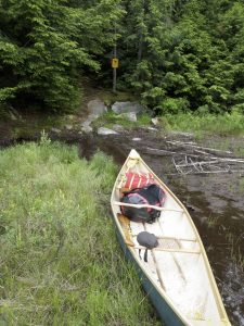
The portage to Little Nunikani was very short (just 30m), so we didn’t unload the canoe and hauled it underhand. It was getting dark as we paddled to our campsite (#63) on the far side of our private lake. We just had time to gather firewood and pitch our tents before dark.

Picture
Picture

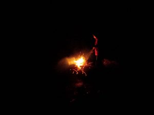
We did manage to get our fire going, but never got enough heat to dry out the big logs that would have made a fire warm enough to dry us out and shake the chill out of our bones. The fire was so anemic that we had to cook our burgers and pasta on our Trangia stove. I looked up after lighting the stove and was shocked to see the sky dotted with stars smeared by the cloudy streak of the Milky Way. The clouds had parted overhead, but there was still a haze on the horizon where we could see thunderbolts flashing and hear the occasional echoing boom of thunder. After eating dinner we lay on the rocks to watch the show before doing the dishes.

Nunikani

It rained a couple of times during the night but not enough to penetrate our defences. When I woke around 7 I could see pink clouds and blue sky through the fly of my hammock. I emerged to a glorious sunny morning, but by the time I had dried out my clothes on the rocks and started breakfast the clouds had rolled back in and the rain had started.

I made a botch of breakfast by putting too much water in the mix, so we had to settle for trail mix. Just as we were packing the canoe to head back it started to rain harder and we decided to wait it out. After about 20 minutes we gave in and paddled out in the rain.

Just minutes after we had hauled our canoe through the short portage to Nunikani the rain stopped, the clouds parted and were greeted with a glorious view of this beautiful lake. We paddled slowly to savour this beautiful, wild little lake. Nunikani is small, but beautifully desolate, with no cottages. We did spot some motor boats stashed among the trees, but none of them were on the water.

At the dam we found the Nunikani cache, and then after taking some photos portaged the boat to the bottom of the rapids. The rapids here are very violent and make for an impressive sight.

Big Hawk Cliffs

The river gave us a push again until we we reached a set of very small rapids that wasn’t on my map. Instead of shooting them we opted to carry the canoe, loaded with gear over the rocks. The shore of the river here is dotted with large stumps that have washed ashore, presumably from Nunikani above the dam.

We rounded the final bend of the river to see the tall cliffs that were once rumoured to contain a native gold mine. Nowhere else do the gravely beaches and rugged shores of Nunikani evoke the valleys of the rockies in BC more. We paddled slowly down this majestic pass, only using our paddles to guide the canoe. Even the tiny cottages that dot the base of the cliffs don’t detract from their impact.

Log Chute

Once we were back on Big Hawk Lake we had a very vigorous paddle to round the point to the marina. The wind had died considerably since the day before, but paddling against it was difficult even for such a brief stretch so we stuck very close to shore. Once we were in the bay leading to the marina it was a relatively easy paddle to the beach.

After we tied the canoe to the car we stopped to visit the last log chute in Ontario (and failed to find the cache there) before starting the long drive home.

As promised in Callan’s book Nunikani is a very scenic trip, and under normal conditions would be quite easy. The heavy winds did make some of the paddling more challenging, but still attainable for a determined novice. My only disappointment other than the weather was the number of cottages that dotted the sore of all of the lakes that we visited with the exception of Nunikani.

Tips

The Haliburton Highlands Water Trails are a managed camping area and require a reservation for overnight camping. They have an excellent website for online reservations. Campsites are booked individually rather than by the lake so you know you know that your site will be available if you arrive late.

Difficulty

  • This is a short trip and the longest portage is only 440m.
  • We had a tough paddle on Red Pine Lake, but I don’t think that was just bad luck.
  • The trip can be easily completed in two days.

Comfort

  • I visited in the late summer and so understandably there were no bugs. I don’t really know how bad they’d be in the spring.
  • The high cliffs on Big Hawk Lake make for some spectacular views which are a bit above other routes in the area.

Remoteness

  • There are a lot of cottages on Big Hawk Lake and several more on Clear Lake and Red Pine Lake. The only lake that feels like wilderness is Nunikani and it has large dams at either end.
  • The weather and the season conspired to keep the crowds away on our trip, but we still saw quite a few people. Even if you manage to avoid other campers it’s quite likely that the cottager traffic will be quite high.

McEwan Lake Loop

I had been hoping to do a few short solo camping trips this year, but for some reason all of the weekends filled up very early and it wasn’t until June that I finally had a chance. When planning an impromptu trip the Haliburton Highlands are much more forgiving than the large provincial parks, and for short trips offer a very similar experience.

Yet again I consulted Kevin Callan’s “A Paddler’s Guide To Cottage Country” for trip planning. This year I selected the McEwan Lake loop, and chose the Wren Lake access to the North. I did decide to modify the route slightly by eliminating the loop at the south end. First, I’m lazy, and didn’t think I’d enjoy the 664m portage between Margaret and Three Island Lakes with my heavy fibreglass canoe. Second, the map at the access point showed one or two cottages on Margaret Lake. Finding a cottage at the midpoint of the trip would spoil the spell a bit so I decided not to risk it. Since I didn’t visit Margaret Lake on this trip I have no idea how built up it is.

Day One

The Wren Lake access point is just a parking lot off the highway, but it is a fairly built up area with lots of cottages. The trip actually starts with a paddle under highway 35, and Wren Lake is ringed by cottages. The cottages end before the falls at the West end of the lake, but there were a couple of girls sunning themselves on the rocks at the lift over when I arrived. I’m not really sure how they got there since they didn’t have a canoe so there must be a trail.

The lift over is quite easy because it’s over solid rock and then a very short paddle and an equally short and easy portage down the small falls led me to a much more remote marsh. Once below the falls I felt like I’d left cottage country and was in a much wilder area. The stream winds its way through the marsh to a slightly more difficult portage at the other end. There’s a small bridge there for an ATV or snowmobile trail, and the trail system does get a bit confusing on the portage so I hiked a bit of it without the pack and canoe to make sure I was going the right way later.

The next portage is the tough one, and I was dreading it a bit. It’s only 228m long, but it’s almost straight uphill. In Callan’s book he mentions that it’s the watershed between Georgian Bay and the Severn river system. The takeout was a muddy mess, and as advertised the hill goes almost straight up. I didn’t even try to do a single carry, I just went in stages going back and forth for my pack and the canoe.

Horse Lake was worth the climb as it is quite pretty. I enjoyed a leisurely paddle, followed by an unremarkable portage to Margaret Lake. My campsite was in view from the portage, and I had the whole lake to myself. By the time dinner was cooked and hung and the fire lit,

the sun had set and I had to beat a hasty retreat to my hammock to escape the mosquitoes. It gets nasty after dark!

Day Two

I stayed up reading pretty late, and then woke up distressingly early. I had to pee, but I didn’t want to leave the protection of my hammock because I could still hear the mosquitoes buzzing. Trying to sleep when you have to pee is pretty futile, so I swung back and forth restlessly.

That’s when I first heard the banging. It sounded like a paddle on the gunnel of a canoe, but it was quite loud and close. I peered out from under my fly to see if I could see a light but there was nobody on the lake at four in the morning. I had finally decided that I must have imagined the sound when I heard it again. It repeated several times at irregular intervals. Whenever I thought it was done it would start up again.

I was beginning to wonder if it was a porcupine chewing on one of my paddles, which would upset me considerably. I yelled to scare off whatever it was but it didn’t work, and the thumping continued. Between the pressure in my bladder, the buzzing bugs, and the banging sound I didn’t manage to get back to sleep. After about an hour the sky was starting to lighten, the banging hadn’t stopped and I still wasn’t sleeping so I decided to run through the bugs, have a quick pee, scare off whatever was after my paddles and get back to bed.

It turns out that the only remaining mosquitoes were all clustered around my hammock and in just a few steps I was free of them. Imagine my surprise when I looked under my canoe and saw a large snapping turtle peeking out from under the bow!

I was taking a few pictures when I heard a sound behind me. I turned just in time to see another snapper jump off the rocks into the water below. It was only a few minutes later when I found a third digging a hole only a meter from the fire pit. Apparently my campsite was a nesting ground for snappers! The turtle who jumped was watching me from the water, and the other two were eyeing me carefully and hissing whenever I approached.

After snapping some more photos I turned around to spot another large snapper crawling though the rocks I was using as a kitchen. I’m not sure if this was a fourth or if the second had come back around, but this turtle was coming from the direction of my hammock, not the water.

After my pee break I completely forgot about getting back to bed so I set about making some oatmeal. By the time I was done the turtles had started to ignore me and I could watch them clamber clumsily over the rocks as I ate my goo.

Mucky Portage

I had an ulterior motive for choosing this destination for my trip. A few years ago while on a winter hike some of the other people I was with hid a geocache on Three Island Lake. Not wanting to log a find on a cache I had essentially hidden I promised to come back one day to claim my smiley. I hung my food and left my big pack at the site and portaged over to Three Island Lake. There was another solo camper there and she was packing up before heading out.

For some reason a seagull on a nearby rock ignored me completely on the way in, but got quite irate when I was leaving and even took to dive bombing me (complete with gooey projectiles). Strange creature encounters that morning. It didn’t take long to find the cache but by the time I was back at my campsite the turtles were all gone. They had left some poorly covered (and broken) eggshells. Hopefully they’ll find a more appropriate place to lay their eggs in the future. I packed up and retraced my route from the first day. It was a thoroughly enjoyable short trip, but I was pretty tired on the drive home thanks to the lack of sleep!

Tips

The Haliburton Highlands Water Trails are a managed camping area and require a reservation for overnight camping. They have an excellent website for online reservations. Campsites are booked individually rather than by the lake so you know you know that your site will be available if you arrive late.

Difficulty

  • This is a very short trip and the longest portage is 664m. I cut that one off. The Horse Lake portage is a bit steep but other than the grade the terrain isn’t very difficult.
  • There are some swifts below the ATV bridge but they can be easily be portaged around.
  • The trip can be easily completed in two days, or even done as a day trip with an early start.

Comfort

This is an area that gets particularly buggy in the spring.

Remoteness

  • There are lots of cottages on Wren Lake, possibly one or two on Margaret Lake, and a bridge for an ATV trail crosses the route but other than that it is quite undeveloped. If you go looking for it you can find a ski warm up hut on Three Island Lake, but it isn’t visible from the water.
  • The route isn’t heavily trafficked and there aren’t many campsites on each lake. One nice thing about Haliburton Highlands is that you can book close to your departure date and the online system lets you see which other sites nearby are booked so you can avoid crowds.

Gun Lake Solo Canoe Trip

I chose this trip as my first solo canoe trip because I wanted a destination that was close to home, not too challenging, but still scenic. The Herb & Gun Lake Loop described in Kevin Callan’s “A Paddler’s Guid To Cottage Country” seemed ideal. None of the portages were long or difficult and it would give me a chance to find a few geocaches on the way.

First Day

Even after driving from Stouffville to Dorset and stopping for a hearty lunch I still had more than enough time to make it to my campsite before nightfall. There was a bit of a breeze when I started and I had to do some vigorous paddling to get going, but the wind soon cooperated and by the time I sailed past the last of the cottages near the put in point I was moving along easily. It was one of those bright sunny days that just overwhelms you with the beauty of the area, warm, but not hot.

Half way along Herb Lake I paddled past a campsite populated by young women in bikinis. I tried not to gawk so as to give them their privacy, but they called out happy helloes and I waved back. It was a long and slightly awkward paddle across the bay in front of their site.

The narrows at the south end of Herb is very scenic. The water level was high enough that the small dam between Herb and Ernest Lakes was awash and I didn’t have to do a lift over, just a shimmy. The Ernst to Brandy portage is quite flat except for a sudden drop at the end. It’s a very easy carry and I was able to manage my pack and canoe at the same time.

The lift over in the middle of the pond was the only one that required me to get out of the canoe. After sliding the canoe over (and getting a soaker) I was starting to wonder if I’d missed the portage. It’s a good thing that I was looking for the sign because I almost went right past it to the falls. The Brandy Falls portage is very scenic where the stream tips over the rocks between the two lakes.

The water winds back and forth through some reeds before opening out onto Gunn Lake. It may have been the perfect weather, or the sun glinting off the water, but Gunn Lake seemed like an ideal spot to be at the time. The pictures on the HHWT websites often don’t do the campsites justice and make the place look a bit dull, but on this bright September day Gunn Lake was truly spectacular.

Even after a late start thanks to the drive, I got to my site by four o’clock and still had plenty of time to make camp, cook dinner and wash up before sunset. With all of my chores done I was able to relax and read my book. I hadn’t been thrilled with my site at first, but it really grew on me as I enjoyed the view of the bay and watched the full moon rise over this pretty little lake. The local beaver had a lodge nearby and was patrolling the bay next to my site, diving frequently with a loud slap of the tail.

I had been a bit worried about sleeping in my hammock in the cool September night, but other than a small draft on my bum I was quite comfortable, and the chill in the air kept all of the bugs away.

Second Day

Reversing my route back to Herb Lake was quite easy. Not only was the weather still perfect, but the wind had obligingly reversed itself so I was paddling with the breeze again. I met some Kayakers at the end of the Herb portage and we chatted briefly about the park and camping in the area.

I took a detour to Knife Lake on the way out to grab a geocache. Since I wasn’t going to camp I didn’t need to bring my pack and made quick work of the first portage. The water between the two lakes is very scenic and deserving of a loftier title than ‘pond’. I think of ponds as overgrown marshy puddles, not scenic pools shadowed by majestic granite hills.

The first portage looked much shorter than the second on my map, but still neither was really of any consequence. When I started the second the sign said 141m, so I was kind of surprised when I saw the water ahead after just a few steps. I checked the sign on Knife Lake, and it too said 141m, but I suspect that someone added a 100m to the length of this short walk on the signs.

When I paddled back through the Herb the girls in their bikinis were gone and I had a quiet paddle back to my car. A loon surfaced right next to my canoe just as I was in view of the takeout point. I still had time to visit the fire tower in Dorset before driving home.

Tips

The Haliburton Highlands Water Trails are a managed camping area and require a reservation for overnight camping. The have an excellent website for online reservations. Campsites are booked individually rather than by the lake so you know you know that your site will be available if you arrive late.

Difficulty

  • All of the portages are flat, relatively level and mercifully short.
  • There are one or two lift overs depending on water levels, neither of which are very difficult.
  • The trip can be easily completed in two days, or even done as a day trip with an early start.

Comfort

The area isn’t particularly marshy or boggy, but I would expect there to be quite a few bugs in the late spring, early summer.

Remoteness

  • There are a few cottages on Herb Lake near the put in point, but it doesn’t take long to leave them behind. I saw a much more rustic looking hunt camp on Knife Lake. While the cottages mean that it isn’t a full backcountry experience they were out of the way.
  • I did see an aluminum fishing boat at the end of the portage to Gun Lake, so it is possible to encounter powerboats on any of the lakes. I didn’t on my trip but in peak season it is probably quite likely.
  • While I didn’t experience much traffic on my trip I expect that in the peak season it gets pretty busy and potentially a bit rowdy. The lack of portages for the Herb Lake sites would be very appealing to partiers, and Gun Lake isn’t much harder to get to.

Cinder Lake Canoe Trip 2010

Cinder Lake isn’t a particularly difficult canoe trip, nor is it as scenic as some of some of the trips in the big parks like Algonquin or Killarney. But it is a lovely beginner trip, and it holds a special place in my heart because it was where I started my adventure with backcountry camping. I’d done some car camping before, but I didn’t know that backcountry camping was even a thing. Then one wintery day I found a truly dismal geocache on the side of the highway because someone in the car needed to ‘up their numbers’. I was wondering if there were any caches worth finding in the area, and I read the description for the nearest cache, “Surviving Cinder Lake”. One of the logs for the cache described an overnight camping trip and referenced Kevin Callan’s “A Paddler’s Guide To Canoe Country”. I was immediately enthralled by the idea.

It took me almost two years to make this trip happen. I booked some camping sites for a trip in 2009, only to have my plans dashed when my wife broke her leg. In 2010 attempts to fix the canoe, the car and other mundane considerations were threatening to push the trip even later in the season when my wife put her foot down and insisted that we use A-Dawg’s canoe and do it immediately. In the years since I’ve read many of Mr Callan’s books, dreamed about many of the trips within, and pursued many of those dreams. Backcountry camping has become a large part of my life, and it all started here.

I planned this trip by combining two of the trips from Kevin’s book. Partly because I wanted a bigger challenge, but also because I was planning the trip around the local geocaches and I wanted to find as many as I could. I still include geocaches in my backcountry trips, but I rarely make them the focus these days.

Apparently most people start out with tons of gear and slowly pare down what they bring as they get more experienced, but I went the opposite route. I had very little money at the time, and almost no camping gear. The only new item I purchased was a Hennessey Hammock. I didn’t even bring a sleeping bag. We had no stove and tried to boil our water and cook our food over the fire. Even though most of our gear wasn’t very ‘technical’ we had so little of it that our only real burden was the crushing weight of our fibreglass canoe. We were too inexperienced to do a solo carry and so we had to struggle with much more awkward two person carries.

Day 1: Cinder Lake

We headed out late in the day Friday, and made our way up to Cinder Lake from the highway access point. The portages were all pretty short, but we soon got tired of carrying our gear and the canoe at the same time so after the first two we started doing them in multiple trips. We took our time, enjoying the views and exploring. I was quite surprised by Ooze lake which was much prettier than its name would suggest. The curved beaver dam by the portage and the trees in the water were particularly nice. We climbed the lookout on Quirt lake, and searched for the sunken logging boat in the North West corner of Cinder Lake that Kevin Callan mentions in his book. We couldn’t find the boat, which is a shame.

By the time we started to head to the east end of Cinder Lake the wind had picked up. Our canoe was trimmed nose heavy (big guy in the front) so the wind would literally spin us around any time we let the bow dig in too much. We carved a crooked path towards our campsite, #65 at the far East end of the lake. We only saw one other group of campers on Cinder Lake, on the small island opposite our campsite. They watched us weave our way towards them while their dogs greeted us with enthusiastic barks.

The geocache description had made me a little worried about the bug situation, so I was quite surprised that we encountered almost none on the way in. Even on the portages there were almost no bugs. Site 65 has the fire pit on a point, so we were protected by the wind and smoke, but while we were eating dinner we could hear an ominous hum coming from the trees. There were no bugs at the fire, but the woods sounded like they were made of mosquitoes! Once I got in my hammock for the night I was literally surrounded by bugs.

This wasn’t my first time sleeping in the hammock, I’d done a few trials at home, but it was my first night ever in the backcountry. I’d pitched the hammock with my feet low, and I kept sliding down towards the far end. I needed to adjust the hammock, but the bugs were so bad I didn’t dare leave it. Sleep is never my friend, but this was a particularly bad night. My hammock was so tilted that I was almost standing, and my ankles were itchy from the bites I sustained as I dashed into the hammock. At one point I slid down so far that I pushed the bottom of the hammock open and a mosquito bit me on the butt. There’s not much room in a hammock, and I had nothing to do, so I was pretty miserably just lying there trapped all night. Ever since that first night I’ve always ensured that I bring a book when camping. I don’t always get a good nights sleep, but at least I’m not bored!

Day 2: Big East Lake

The next morning I made the worlds worst pancakes and we watched our neighbours paddle away before we headed over to find the “Surviving Cinder Lake” geocache. I was shocked when I opened the log book and saw that it had been signed by ‘Merlot And Shiraz‘ the day before! Our neighbours were also geocachers! This cache only gets found a few times a year, and here we both went out to find it on the same day and camped within a kilometre of each other. We kept expecting to encounter them on our trip out and then down to our next camp site on Big East Lake, but they were far ahead of us.

After finding “Surviving Cinder Lake” near our morning campsite we paddled down to the parking lot to resupply, and then to our campsite on Big East Lake. After the remote serenity of Cinder Lake and the many portages Big East felt like the Club Med of backcountry camping. There were large groups of people partying with multiple canoes full of gear. They had lawn chairs, music and big dinning tents to go with their small sleepers. Big East is a very scenic lake, and despite the packed campsites it never felt crowded.

Even though there were no portages, Big East had it’s own challenges. The large open stretches of water would really pick up the wind, and we had to work to stay on course, first heading West in the North section, and then heading South. There was a brief interlude of calm in the narrows, but other than that it was a tough paddle to get to the island where we were going to camp. When we did get to the island I decided to push on to find the “South End Of Big East” geocache because I was worried about the weather on Sunday morning – there had been threats of rain, and I didn’t want to have to dash out without finding the cache.

As we rounded the South corner of the island the wind became truly fierce and the waves turned to small whitecaps. It was very difficult to cross the bay, and I barely had a chance to glance at the GPSr. We landed on the wrong side of the peninsula and hugged the shore as we went around. Out of the wind it was incredible weather, bright sunny sky and warm without being uncomfortably hot.

There was a young couple sunning themselves on the rocks near the hunt camp, and at first I thought that they were residents, but when I saw their canoe I realized that they were campers like us. We followed the needle on the GPSr right past them and into the channel with the beaver dams. The cache was very easy to find, and in a beautiful spot.

We turned around and headed back to our campsite with the wind at our back. Site #24 is right at the intersection of two islands, and there’s another campsite nearby (I believe that they share a thunder box). There was another group at the other site, but we never saw them, so there is a reasonable amount of privacy.

We found our third cache of the day “Big E”, right next to our campsite. We actually visited the cache location about three times while gathering firewood before changing our priorities and finding the cache. It was a fairly easy find in a lovely area of the island that just happened to afford a view of the privy for our campsite . We had a very nice night. It did get a bit cold, particularly since I had no sleeping bag, but I was tired enough that I slept better than the night before.

Day 3: Home

Xander woke up in the night and had a snack from the ‘bear bag’. We’d made an embarrassing newb mistake. Since we were camping on an island we figured bears wouldn’t be a problem (new flash — bears can swim) and so we hung our bag at ground level not far from our site. Our hang the first night wasn’t much better though, as we made another mistake then. We hung the bear bag right next to the trunk of a tree that was right in our campsite. There was nothing to stop a bear from climbing up and grabbing it. I’ve hung many bear bags since those first two, and my technique has improved, but I’d say only about half of them have been truly bear proof. It’s always a humbling experience to try to do what seems like such a simple task and realize how difficult it is to do properly.

I woke up early and spent some time alone lounging on the rocks and taking photos while I waited for Xander to wake up. I had worried before this trip that I wouldn’t have enough to do. One thing that I’ve learned is that there’s always something to do on a trip, and I seem to have an endless capacity for contemplating the world while sitting on a sunny rock after a night in the hammock. I’m usually not much of a morning person, but I really enjoy them when I’m ‘out there’. I was enjoying myself so much that I had to force myself to start the day’s chores.

After we made breakfast and struck camp we decided to try a trip to Moose Track Lake (recommended by our guide map) since the day was still young and beautiful. It didn’t take us much time at all to reach the North end of the lake, and we made it quite a distance into the bog at the eastern end, before we were thwarted by a beaver dam and decided to turn back. We had just put the canoe down next to the car when a light sprinkling of rain began.

Tips:

The Haliburton Highlands Water Trails are a managed camping area and require a reservation for overnight camping. They have an excellent website for online reservations. Campsites are booked individually rather than by the lake so you know that your site will be available if you arrive late.

Difficulty

  • The portages on the north loop to Cinder Lake are all short and none are particularly difficult but there are quite a few of them which can make progress slow. Overall the north loop is still quite short and easy.
  • The south loop has no portages, just the carry down from the parking lot.
  • While Big East Lake isn’t particularly big, it can act as a funnel for the wind making travel a bit more difficult at times.

Comfort

  • Cinder Lake was particularly buggy at night. In the daytime the bugs were quite normal.
  • The island campsites on Big East Lake weren’t very bad at all for bugs.

Remoteness

  • There are two cottages on Big East Lake and there’s what looks like an abandoned ranger cabin on Cinder Lake. Other than that there’s no infrastructure in the area.
  • The further you get from the highway the fewer people you’ll meet. Cinder Lake doesn’t seem to get much traffic at all, but Bentshoe Lake and Big East Lake are quire crowded due to the easy access. If you want an easy trip head south to Big East, if you don’t want crowds head north.
  • When I first did this trip the road to Cinder Lake was closed so the only access was by portage. The last time I visited the road had re-opened and there was actually someone car camping on Cinder Lake.